MILITARY-TOPOGRAPHIC SERVICE IS 20!
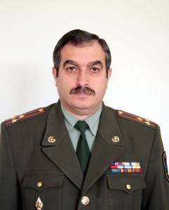
Interview with RA AF GS Military-Topographic Department Head Lt.Colonel Gevorg Manoukyan
 – Mr.Manoukyan, please tell about the formation of the service and its contribution in the Artsakh war.
– RA armed forces Military-Topographic service was created in September, 1992, its first head was Colonel A.Azizyan. On November 28th the first map was published. In the first years the structure’s aim was to support with topographic maps our troops in war. The first stage of its activity (1992-96) I would describe as formation period. That time we used also the potential of the Institute of Geodesy & Cartography. Owing to brilliant specialists (Captains Youra Varyan, Smbat Davtyan, ensign Lydia Grechukha) and proper organization, the structure was able to fulfill the tasks put by – to support army with topography maps, to investigate localities, renew maps, make locality models.
– On which level is the international cooperation?
– If till 2006 the AF Military-Topographic Service was member of Topographic Services Committee of CIS countries, since 2006 cooperation started with NATO in the framework of the program “Partnership For Peace”. Today we have bilateral cooperation with Russia, Belarus, Ukraine, Kazakhstan, Great Britain, Germany, Bulgaria, etc. A Memorandum of cooperation is signed with Great Britain.
Category: #49 (965) 13.12.2012 – 19.12.2012, National army, News, Spotlight


